National Parks & Biodiversity on Paths
Stage 3: How to carry out the investigation.
Method 1: Interrupted belt transect with measurement of
% cover in 0.5m quadrat squares.
Apparatus:
- 25m measuring tape.
- 0.25m string or rope.
- x4 securing poles.
- 0.5m quadrat.
- Recording sheets.
| - Clip board
- Compass.
- Identification sheets.
- Digital camera
- Inclinometer to measure the angle of the slope.
|

 |
|
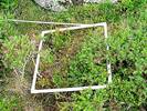
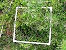
Belt Transect in action - Click to enlarge |

Belt Transect
A belt transect uses a 0.5m quadrat, measuring tape and string.
- The string is run across the path (at right angles to the path) along the ground. It is held in place by two poles.
- Another line is laid parallel to this and 0.5m from it, creating a ‘belt’ transect across the path. At every metre point along the transect line, lay down the 0.5m quadrat.
- In this square, record the % cover (to the nearest 5%) and the name of each plant. Include those plants that overlap into the square. You can sub-divide the quadrat into smaller squares, which will help you to estimate the % cover for each species.
- This is repeated from one end of the line to the other.
- Where there are no plants, bare earth is recorded.
- If you work in pairs, one can record whilst the other estimates % cover etc. You can discuss the estimated % cover, which helps to improve accuracy.
- In the square, record the height of the tallest vegetation to the nearest cm.
- Also note any rock or bare earth. Also note the orientation of the transect, using the compass.
- The inclinometer is then used to determine the angle of the slope of the path over each sample area.
Because this method is quite slow, you may only be able to carry out one belt transect. If you have time, repeat at another location on the path. As far as possible, the lines should be at right angles to the path.
 Download a sample recording sheet.
Some practical points:
- Using quadrats along a transect is known as a ‘directing counting’ method. If the number of organisms found in a certain number of quadrats is known, and these represent a known fraction in a given area, the total number of organisms can be calculated – in this investigation, this is not possible. Species diversity, species density and species cover can be calculated.
- There are problems in assessing % cover when species overlap and you may have a % cover which exceeds 100%!
- Calculating species frequency may also be difficult as it may be a problem to isolate and count individually rooted plants. Plants that overlap the area but are not rooted need to be treated in the same way e.g. they are or are not included. In this investigation, counting individual plants is not possible.
Definitions
- Species density is the number of individuals (rooted) of a species in a given area.
- Species frequency is a measure of the probability of finding a given species (rooted). If it occurs in 2 in 10 quadrats, it has frequency of 20%. The quadrat size needs to be stated since it will have an effect on the frequency.
- Species cover is a measure of the proportion of ground covered by the species – this can be more useful than species frequency when isolating individual plants is difficult.
 Method 2: A line transect


 Method 2: A line transect
What's your opinion?
Average rating


Not yet rated